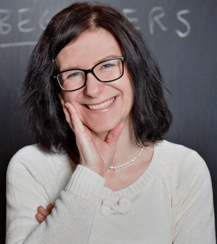
Nezbytné
Technické cookies jsou nezbytné pro správné fungování webu a všech funkcí, které nabízí.
Ancient Mapmaking
Článek byl vydán 26. března 2018
Seniors love to travel. The article about Ancient Mapmaking refers to its history and interesting facts about how maps looked like in past and which kind of people used to buy maps with many decorations mapping illustrations of fantasy better than real illustrations.

Giovanni Battista Cavallini's 1640 map of the Mediterranean Sea filled with decorative elements
Inventing cities, mountains, and monsters to fill the empty spaces on maps is a centuries-old tradition in cartography.
The Indian Ocean is filled with sea monsters in Caspar Vopel’s 1558 map of the world.Animals are emerging from the water or swimming towards ships, and a king is riding the waves on top of an ugly beast.
Vopel, a German mapmaker, did not explain why he added these things to his map, but maybe he was afraid to leave the empty spaces undecorated.In dozens of maps, mapmakers have filled the empty spaces with mountains, monsters, cities, and other illustrations of fantasy.This was common, especially during the 16th and 17th centuries.
One good reason mapmakers did this was because many areas of the world were still not mapped.Also, maps were desired by aristocrats and other rich patrons, who expected lavish decoration.In 1640, Italian cartographer Giovanni Battista Cavallini made a colourful chart of the Mediterranean Sea showing the surrounding land filled with cities and mountains.
But by the middle of the 18th century, more and more mapmakers kept their decorations at the sides of the map, leaving the seas and continents without decoration.From that time onwards, mapmakers started to think of maps as something more scientific.
Source: nationalgeographic.com.